Cyprus Subsea Consulting and Services C.S.C.S. Ltd is happy to announce the launch of a new service – an Ocean Data Interface.
As a member of the STEAM Project, CSCS built an environmental data sharing platform for the maritime sector. One of STEAM’s tasks is to incorporate innovative technological solutions to provide real-time information regarding the state of the sea. This data sharing platform increases the effectiveness, efficiency and safety of port operations with valuable information to all actors involved in marine navigation.
As sea-traffic and trade hubs, ports increasingly demand environmental data. Environmental sustainability is becoming more pertinent to stakeholders responsible for the health and safety of these ports. In addition, comprehensive datasets assist stakeholders with decision making and confirm they’re complying with strict environmental regulations and standards. To this effect, CSCS created the Ocean Data Interface with two types of map-based interfaces. These interfaces display environmental monitoring data related to various parameters.
Copernicus Marine Environment Monitoring Service
Copernicus Marine Environment Monitoring Service (CMEMS) provides most of the data presented in this Ocean Data Interface. To summarize, CMEMS offers access to hindcast, current and forecast data as well as remote sensing, in situ data and merged products.
Other sources of data include the Skiron weather forecasting system courtesy of the developer, Professor George Kallos at Weather & Marine Engineering Technologies P.C. The data set provides a very high-resolution (5 km) weather forecast with an hourly output.
Ocean Biogeochemical Parameters
The Ocean Biogeochemcial Parameters Interface utilizes a GIS tool in conjunction with the Web Map Services (WMS). This embedded interface displays ocean biogeochemical near-real time data from CMEMS. These parameters displayed in a comprehensive, user friendly and interactive manner include:
- Mass Concentration of chlorophyll-a in Sea Water
- Dissolved Inorganic Carbon
- Mole Concentration of Nitrates
- Mole Concentration of Phosphates
- Sea Water pH
Sea Physics & Meteorological Parameters
The Sea Physics & Meteorological Parameters Interface presents datasets specific to the entire Mediterranean Sea including:
- Currents
- Temperature – Physics Model
- Temperature – Remote Sensing
- Waves
- Winds & Air Temperature
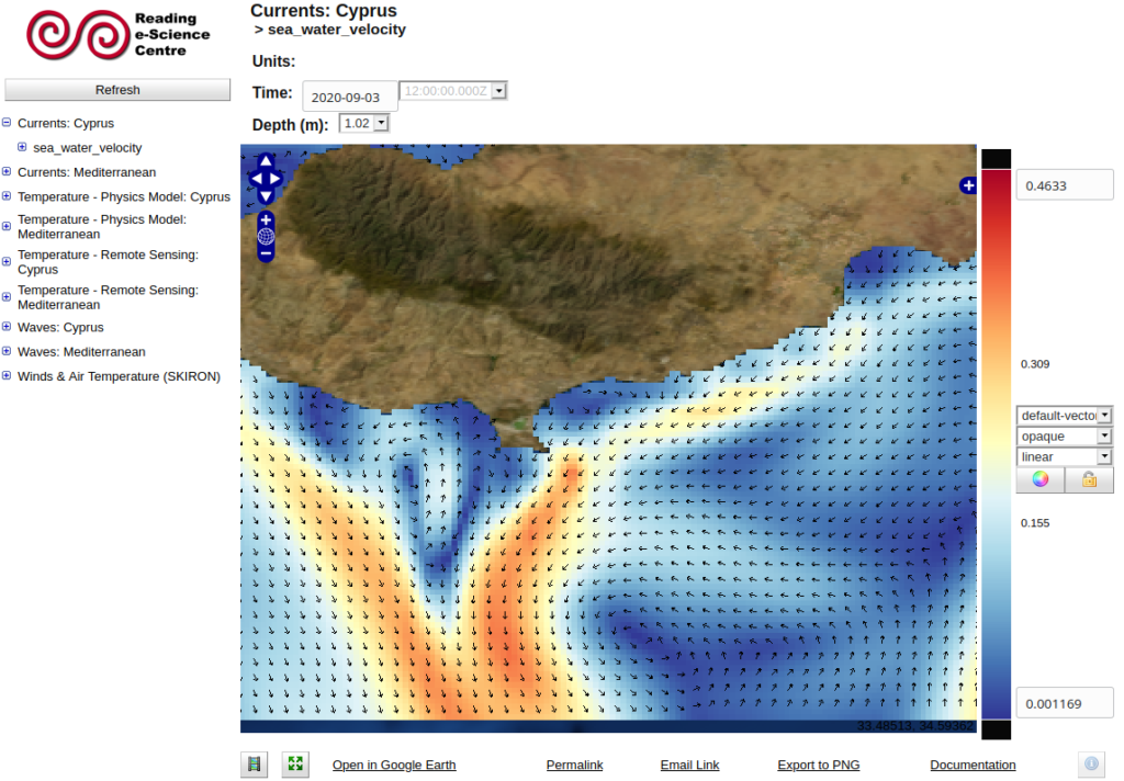
Moreover, this interface includes datasets that have been processed to produce fine-scale view of the coast around the Republic of Cyprus.
The ncWMS is an open source software for visualizing and exploring geospatial data. As a component of the software, the Godiva3 interface displays CF-compliant Network Common Data Form (NetCDF) files on a web page. This ncWMS is developed and maintained by the Reading e-Science Centre (ReSC) at the University of Reading, UK.
After accessing the Godiva3 interface, users have a range of options after selecting a variable on the left-hand menu. Once the data displays on the interactive map, users can:
- navigate the map & use controls (top left of the map) to zoom in & out
- select date & time using the drop-down “Time” box (above the map)
- click on the map to discover the data value at that point
- access links to generate time series / vertical profile plots
- create an animation (click on the filmstrip button below the map)
- create transects along arbitrary paths
- change the background map
- save & email the view
- export a static image of the current view
Building an interface for your needs
Our Ocean Data Interface provides today’s conditions, plus several days in the future and in the past, enabling real-time situational awareness. In addition, meteorological data serves as an early weather warning system for ship managers and port control center. Participants in maritime activities in the Mediterranean can utilize this platform for the purposes of increasing operations efficiency, environmental sustainability and maritime safety.
Please contact us for further information. We can develop custom interfaces and analysis, including the time span, depth ranges and parameters of interest for your application.